

Visorando - Walking routes
In-app purchases

4.5star
106K reviews
5M+
Downloads

Rated for 3+
info

About this app
Visorando helps find curated route ideas and turn your smartphone into a recreational GPS, even offline.
Millions of people use the mobile app to explore paths worldwide.
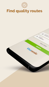
📂 A WIDE CHOICE OF ROUTES
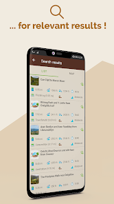
Find routes all over the United-Kingdom, matching your own needs for free - whether it’s a hike in the mountains or a stroll in the countryside, along the coast, into the woods or even in the city-even abroad. From a family walk to a strenuous hike, for a ramble on your doorstep or your next holidays, find what suits you best ! Walk or cycle, choose your own activity depending your location, the level and the duration you wish.
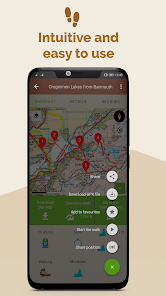
Each route sheet includes an OpenStreetmap map, a GPX, a step-by-step description, length, elevation gain, maximal and minimum altitudes, elevation chart, points of interests, level, weather forecast, and depending on user’s contribution photos and reviews.
Find more than 26 000 curated routes available world-wide (more than 3 500 of which in English).
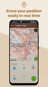
🗺️ LOCATE YOURSELF ON THE MAP AND LET BE GUIDED, EVEN OFFLINE
When you found the right itinerary, download it offline before leaving, then press the button start to follow the route. The GPS app will guide you even off the grid. You will be able to see your live location and your real time progress on the map. If you go off-track, an alert will warn you.
While moving, the actual route is recorded so afterwards you can share it, analyse it, compare it with the one plotted or simply walk it again later.
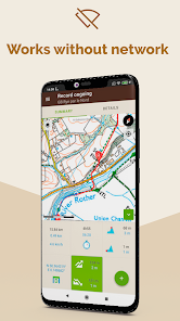
📱 PLOT AND RECORD YOUR OWN CUSTOMISED ROUTE
Doesn’t any of the route suits you? No worries, you can :
- Plot your own route, thanks to our route planner available for free from your laptop via our website (and from your mobile phone if you subscribed to Visorando Premium). When your route is saved on your computer, an automatic synchronisation allows you to find it over all your devices (mobile phone, tablet) where you are connected with your Visorando account.
- Record a live route and follow your progress on the map (distance, duration, elevation gain…). If you lose
yourself, you will be able to find your way back by following the route you just recorded.
- Import a GPX file
⭐ VISORANDO PREMIUM : Premium subscription to explore even further
We offer Premium Visorando during a 3 days trial period when you first register on the app. Then, you can subscribe for £5/month or £21/year.
Visorando Premium give you access to several add-on features such as :
- Access a collection of licensed topographic maps from your mobile phone : OS Explorer, IGN France, Swisstopo Switzerland, Belgium and Spain.
- Share you live position to reassure your loved-ones
- Hour per hour, detailed weather forecast of your route
- Organise and create files to keep your routes in order
- And many more…
Manage your subscription and choose if you wish to have it automatically renewed or not.
⭐ OS EXPLORER MAPS : the reference for any outdoor lover
Users who subscribe to Visorando Premium have access to the OS Explorer maps 1:25 000 scale on mobile phone : it allows to precisely visualise, elevation, contours, details related to the terrain. It also offers many information related to tourist and leisure activities, and gather national trails and other public right of ways.
🚶 A QUALITATIVE CONTENT
Visorando is a participative platform and community where anyone is welcome to share his/her own route. To assure the quality of the route published, each submitted one goes through a process composed by several steps, where it is checked and edited by a team of volunteers and agreed with the author, before being published.
📖 MANUAL
A manual to help you use the mobile app is available here : https://www.visorando.com/en-gb/article-user-guide-how-to-use-the-app-visorando.html
Millions of people use the mobile app to explore paths worldwide.
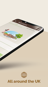
📂 A WIDE CHOICE OF ROUTES
Find routes all over the United-Kingdom, matching your own needs for free - whether it’s a hike in the mountains or a stroll in the countryside, along the coast, into the woods or even in the city-even abroad. From a family walk to a strenuous hike, for a ramble on your doorstep or your next holidays, find what suits you best ! Walk or cycle, choose your own activity depending your location, the level and the duration you wish.
Each route sheet includes an OpenStreetmap map, a GPX, a step-by-step description, length, elevation gain, maximal and minimum altitudes, elevation chart, points of interests, level, weather forecast, and depending on user’s contribution photos and reviews.
Find more than 26 000 curated routes available world-wide (more than 3 500 of which in English).
🗺️ LOCATE YOURSELF ON THE MAP AND LET BE GUIDED, EVEN OFFLINE
When you found the right itinerary, download it offline before leaving, then press the button start to follow the route. The GPS app will guide you even off the grid. You will be able to see your live location and your real time progress on the map. If you go off-track, an alert will warn you.
While moving, the actual route is recorded so afterwards you can share it, analyse it, compare it with the one plotted or simply walk it again later.
📱 PLOT AND RECORD YOUR OWN CUSTOMISED ROUTE
Doesn’t any of the route suits you? No worries, you can :
- Plot your own route, thanks to our route planner available for free from your laptop via our website (and from your mobile phone if you subscribed to Visorando Premium). When your route is saved on your computer, an automatic synchronisation allows you to find it over all your devices (mobile phone, tablet) where you are connected with your Visorando account.
- Record a live route and follow your progress on the map (distance, duration, elevation gain…). If you lose
yourself, you will be able to find your way back by following the route you just recorded.
- Import a GPX file
⭐ VISORANDO PREMIUM : Premium subscription to explore even further
We offer Premium Visorando during a 3 days trial period when you first register on the app. Then, you can subscribe for £5/month or £21/year.
Visorando Premium give you access to several add-on features such as :
- Access a collection of licensed topographic maps from your mobile phone : OS Explorer, IGN France, Swisstopo Switzerland, Belgium and Spain.
- Share you live position to reassure your loved-ones
- Hour per hour, detailed weather forecast of your route
- Organise and create files to keep your routes in order
- And many more…
Manage your subscription and choose if you wish to have it automatically renewed or not.
⭐ OS EXPLORER MAPS : the reference for any outdoor lover
Users who subscribe to Visorando Premium have access to the OS Explorer maps 1:25 000 scale on mobile phone : it allows to precisely visualise, elevation, contours, details related to the terrain. It also offers many information related to tourist and leisure activities, and gather national trails and other public right of ways.
🚶 A QUALITATIVE CONTENT
Visorando is a participative platform and community where anyone is welcome to share his/her own route. To assure the quality of the route published, each submitted one goes through a process composed by several steps, where it is checked and edited by a team of volunteers and agreed with the author, before being published.
📖 MANUAL
A manual to help you use the mobile app is available here : https://www.visorando.com/en-gb/article-user-guide-how-to-use-the-app-visorando.html
Updated on
Safety starts with understanding how developers collect and share your data. Data privacy and security practices may vary based on your use, region, and age. The developer provided this information and may update it over time.

No data shared with third parties
Learn more about how developers declare sharing

This app may collect these data types
Location, Personal info and 2 others

Data is encrypted in transit

You can request that data be deleted
Ratings and reviews
4.4
104K reviews

Leigh R
- Flag inappropriate
April 16, 2025
Great start to using this app but it would be even better with a voice given basic directions, i.e. when to turn left or right. It'd save having to keep looking at the app. I like the data it gives you, especially how far you've walked and time elapsed. Looking forward to using the app again as it is one of several in my hiking 'arsenal'. Thoroughly enjoyed the walk too.
1 person found this review helpful

D. Leveratto
- Flag inappropriate
- Show review history
May 30, 2020
Probable bug since it does not stop a walk when it has started recording it. I have tried everything: to stop, to pause, to start a new track.. nothing worked out. This consumes battery and memory as well. Also, 'around me' does not work. To find a track, the search function does not work. I thus uses Google, then download track , then open it with Visorando. Not really straight forward.. It could be improved...
9 people found this review helpful
Visorando
June 1, 2020
Hello. Could you contact us (webmaster@visorando.com)? We will help you with settings. Best regards. Hélène

Honey Babou
- Flag inappropriate
January 15, 2021
I live in France and I can only download the UK version! Which means the app never finds any walk around my location. My father has the French version and he can choose among tons of walks. Also, the menu on his version has many options to define the search (as in the picture on the app store) and I have only one, ie the type of activity. I tried downloading several times and also changing settings on my profile on the website. Help would be appreciated!
5 people found this review helpful
Visorando
January 6, 2023
Hi Honey Babou, I am happy to let you know the English version developed a lot lately! Normal settings to search a walk will be in English only so please change it settings: manage menu>settings>search in all languages>yes. Now when you search you will have a list of walks in English, German and French. We translate them all ourselves that's why.😊
What’s new
- Reports: During a walk, you can now report events on your route to the community. These reports are collaborative
- Elevation source during the walk: You can now choose between GPS elevations or the elevations of the Digital Elevation Model
- Add popup to inform if too many downloaded maps
- Fix orientation bug in some situations
- Fix deeplinks issue on forum / rating links
- Elevation source during the walk: You can now choose between GPS elevations or the elevations of the Digital Elevation Model
- Add popup to inform if too many downloaded maps
- Fix orientation bug in some situations
- Fix deeplinks issue on forum / rating links
App support
About the developer
VISORANDO
webmaster@visorando.com
6 RUE DE L INDUSTRIE
68360 SOULTZ HAUT RHIN
France
+33 7 66 27 13 38


